Computer Vision Gives a Clearer Picture of our Past
Computer vision techniques are providing insights into history that are truly remarkable. As imaging technology advances, so does our knowledge of how the modern world was shaped.
LiDAR and archaeology
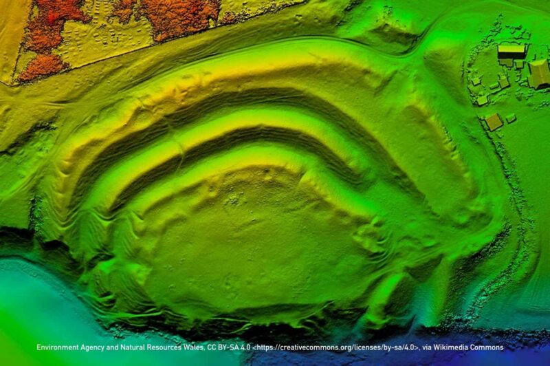
Combining LiDAR (Light Detection and Ranging) and computer vision has proven to be a powerful method for uncovering hidden ancient structures in archaeological research. LiDAR can penetrate dense vegetation by emitting laser pulses and capturing the return signals from the forest floor beneath. This results in highly detailed, 3D maps of the terrain, showing features like ancient roads, buildings, and other man-made structures that would otherwise remain hidden.
Once LiDAR data is collected, computer vision techniques can be applied to process and analyze the massive amount of data. Algorithms can identify patterns, highlight potential archaeological sites, and create models that reveal the layout of forgotten cities.
For example, in the early 2010s, researchers used this combination to discover previously unexplored Mayan cities in the jungles of Caracol in western Belize. Archaeology Magazine reported that “Just a few days of flyovers and three weeks of processing yielded a far superior picture of Caracol than on-the-ground mapping ever had.1”
On the other side of the world, more drone-based LiDAR imagery led to the discovery of two medieval cities along the ancient Silk Road trade route. Nestled in the mountains in Tashbulak and Tugunbulak in Uzbekistan, the images revealed defensive walls, watchtowers and a central fortress. The trading hubs were likely to have grown from the 6th century before declining in the first half of the 11th century.
The fusion of LiDAR’s depth data with computer vision’s ability to recognize and interpret visual patterns accelerates the understanding of hidden urban landscapes and ancient civilizations. This offers an exciting, non-invasive method for exploring historical sites.
Historical imaging boosted by AI
AI is supercharging research projects in every sector, including scrutinizing ancient texts. The Vesuvius Challenge is a competition that aims to reveal legible writing from charred strips of the Herculaneum scrolls.
The scrolls were damaged in the eruption of Mount Vesuvius in AD79 and nobody thought it would be possible to decipher the text on more than 600 scrolls, which are too badly damaged to be unrolled. In 2015, researchers using X-ray tomography and computer vision algorithms began the first “virtual unwrapping” of the scrolls. Virtual unwrapping uses a series of techniques starting with 3D unstructured volumetric scanning and results in a 2D image of the hidden text without even needing to touch the parchment.
In March 2023, the organizers of the Vesuvius Challenge released high-resolution CT scans from the scrolls and entrants were challenged to recover four passages of 140 characters. Researchers applied classification algorithms, segmentation tooling, convolutional neural networks (CNNs) and other techniques to the images of scraps of text in a bid to win the grand prize of $700,000. The winning team succeeded in recovering 85% of the characters in the passages.
Virtual unwrapping was also used in 2016 to view the En-Gedi scroll, first discovered in 1970 at the site of an ancient synagogue in En-Gedi, Israel. Read a full explanation of the process of virtual unwrapping of the scrolls. The team behind this process has been able to ascertain that the scroll contains text from Leviticus and even assume that the ink used is likely to contain iron or lead.
Underwater imaging reveals the past
While we don’t always think of vision and hearing being related, sonar imaging is a novel way to combine the two. In December 2024, Novus Light reported on high-resolution sonar developed by maritime surveillance experts ThayerMahan being deployed by US researchers near the island of Attu in the Bering Sea. The sonar technology was used alongside the World Scan Project’s ROV-mounted camera systems.
Three World War II-era shipwrecks were discovered, as well as artefacts such as anti-submarine netting and sunken buoys. These all help to recreate an understanding of events at a time when facts were often shrouded in secrecy and misinformation.
Getting Personal
Computer vision can also be used to reveal more about your own history. Several genealogy platforms offer a feature where users can upload a photo and facial recognition algorithms go to work to spot features that might be inherited.
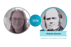
For example, Family Search offers Compare a Face, where you can compare your face to those of your relatives to see who you most resemble. Or indeed, if you share features with any famous faces. It’s quite a fun tool, and apparently, I share 30% of my facial characteristics with Charles Darwin!
Advanced Imaging Technologies
Computer vision is revolutionizing historical research by unlocking new ways to analyze, preserve, and interpret the past. From deciphering ancient texts to discovering lost cities, these technologies bridge the gap between history and innovation, allowing researchers to uncover insights that were once out of reach.
Our imaging products have supported numerous research projects around the world. For example, one customer uses our FireBird frame grabbers in their bid to preserve history for future generations. Take a look at how else our cameras, frame grabbers and embedded systems are ideal for use in research projects.
1. Archaeology Magazine – Lasers in the Jungle – Archaeology Magazine Archive